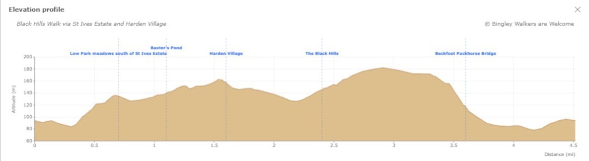
This 4.5-mile circular walk traces a fascinating loop through one of Bingley’s most layered landscapes. Leaving the town centre, the route climbs through the meadows and woodland of St Ives Estate – shaped across two centuries by the Ferrand family, who called it home from the 18th century onward. The estate’s open Low Park meadows and the shade of Cuckoo Nest woods give way to a steady climb out through Harden village to Banktop, where the view opens up across the valley toward the Black Hills plantation and Ruin Bank Wood – the latter home to Saint David’s Ruin, a Ferrand folly hidden within the pine plantation and not accessible from the public right of way. The return drops back down to Beckfoot pack horse bridge, one of the oldest crossings on Harden Beck, before the path leads home through Myrtle Park to Bingley. Allow around 2.5 hours, with some steep sections on both the ascent and descent.

View of Black Hills from Banktop in Harden
Plan your walk
Where to start?
Bingley Arts Centre
Main Street
Bingley
West Yorkshire
BD16 2LZ
Grid Reference SE 106 390
Bingley Railway Station is only a step away from the start of this walk making it a car free train walk! We encourage walkers to use public transport as much as possible.
We have provided an interactive map below, powered by OpenStreetMap. You can zoom in and out, explore the route in detail, follow your live location along the walk, and view points of interest, cafés and facilities directly on the map.
Elevation profile
Route files for GPS & mapping apps
Find out more about these downloadable files and how to use them
Toilets & Refreshments
There are public toilets on this walk and are located on Myrtle Place (by the market square) in Bingley. There are also some free and unattended toilets next to the playground within St Ives Estate.
There are many shops, cafés, restaurants and pubs in town but below are specifics businesses which we recommend if you go on this walk. Feel free to visit their site and contact them.
A traditional pub near Harden Beck Bridge.
A Garden & Leisure Centre on Harden Lane hosting a café serving good comforting food.
A multi-award-winning café and small family business in the heart of Bingley
Walk Directions - Black Hills Walk via St Ives Estate and Harden Village
Last edited: 6th June 2026
1. From Bingley along the River Aire to St Ives Estate
Starting outside Bingley Arts Centre, head right past the old covered market and buttercross toward the car park. At the bend in Queen Street you will find the entrance to the Riverside Walk. Go down the stairs, turn left at the bottom and follow the path along the River Aire toward Myrtle Park. Cross the green tubular steel bridge and climb straight up through the wooded area ahead. At the top turn left, then shortly after take the right path up the hill and through the woods to Harden Road. Bear left along the pavement toward the St Ives entrance and cross the road at Beckfoot Lane – you are now entering St Ives Estate.
Note: see the walk Discovering Bingley: Walk to Gilstead Crag & Gilstead Moor for more info about the town centre features.

Plaque on riverside footpath with text: "The Throstles Nest of Old England Bingley"
2. Through St Ives Estate: Low Park and Cuckoo Nest Woods
The path climbs up to the estate’s main road. Cross the road – the large open meadow of Low Park is directly opposite, with a stile in the fence on the other side. Do not go towards bottom car park, whose signs you will see further along to your right. Walk through the meadows, crossing two further stiles before bearing right toward the wood’s edge, with a ruined barn visible on your right. Go through a small iron gate into Cuckoo Nest woods. Follow the path through the yew trees, crossing a small wooden bridge, until you reach a junction. Turn left toward the building and take the left path signed “footpath Harden". Just past the building, a short detour to the right brings you to Baxter’s Pond, a peaceful water feature worth a pause. Return to the path, follow it past a small stream and through a kissing gate, then bear right and take the path up along the wall. At the next junction take the left path signed “footpath Keighley Road", passing a rock carved with steps and a metal handrail. The path ends at the Western Entrance, where you will see St Ives Lodge, also known as Beckie’s Lodge.

Magnificent oak trees in Low Park Meadows in St Ives Estate near Bingley
Bradford Pennine Gateway is part of one of the The King's Series of National Nature Reserve
3. Keighley Road through Harden village to Banktop
Turn left down Keighley road towards Harden village. Cross Harden Road carefully (there is a crossing up the road on your right) and then walk along Wilsden Road. This will take you all the way to Harden Beck – walk on the bridge carefully as there isn’t any pavement.
Note: On the other side of the bridge is The Malt Shovel pub, a great traditional public house serving home made food – a welcome stop if you need a break.
Continue up Mill Hill Top rather than walking along the busy Harden Lane, passing Stephen H. Smith’s Garden & Leisure Centre – now trading as Bingley Garden Centre.
Note: the café at Bingley Garden Centre, Hattie’s Restaurant is well worth a visit.
Cross the busy Harden Lane at the Garden Centre main entrance, where you will find a kissing gate in the opposite wall. Walk down the path and cross Mytholme Beck on a wooden bridge, then go through the gate. Veer left toward a steep path – either follow the main path with a building above, or take the steeper path alongside the wall on your left. At the top you will reach the entrance to a working quarry and join Lee Lane, a tarmacked road. Pass Banktop Farm and continue until you see a footpath sign on the left turning into a field. This is the Millennium Way, leading toward the Black Hills.

This path near Harden Lane crosses Mytholme Beck over a wooden bridge

Yorkshire Stone Product sign at Banktop Quarry
4. From the Black Hills to Beckfoot Pack Horse Bridge and Bingley
Follow the Millennium Way across the fields, with Norr Hill visible on your right in the distance. Enter the Black Hills plantation and continue until you reach a crossing of paths.Turn left and descend via a steep and rough path out of the plantation. As you emerge, there are beautiful views across the Harden Valley with St Ives Estate opposite. On your left, Harden Grange – the Ferrand family’s original home before the 1858 name swap with St Ives – is visible across the valley. Follow the path across the field bearing right, then cross a stile into Shipley Golf Course, following the white rocks toward Beckfoot Lane. Cross Harden Beck on the footbridge and turn right toward the ancient Beckfoot Pack Horse Bridge.
Note: if you turn left on Beckfoot Lane and walk all the way up you will end up on Harden Road near the entrance to Bingley St Ives bottom car park.
Take your time at Beckfoot Pack Horse Bridge – one of the most picturesque spots in Bingley. Cross the beck a second time and pass the small settlement of houses, then follow the tarmac road along the allotments on your left. Turn left onto a footpath, keeping the allotments on your left, toward Myrtle Park. Cross the River Aire on the large steel bridge and head through the park past the playground and the cenotaph toward the exit. Bingley Arts Centre is a short walk from the park entrance.
Note: The Loft Café Bar on Main Street is a great stop at the end of your walk. In Summer they have an outdoor seating area in Jubilee Garden opposite Bingley Arts Centre.

View of Norr Hill from Banktop in Harden before enterring the Black Hills plantation
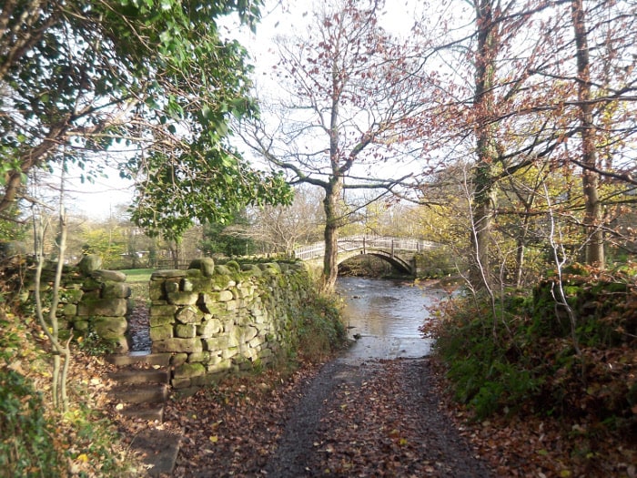
Bottom of Beck Lane in Bingley, near Pack Horse Bridge over Harden Beck
The Ferrand Family and Harden Grange
The Ferrand family’s connection to the land around Harden stretches back to at least 1582, when they acquired a substantial landholding in the area. Over the following centuries they shaped much of the landscape you walk through today, planting woodland, creating meadows and building the estate that became St Ives. The greatest of the Ferrands was William Busfeild Ferrand, MP for Knaresborough and a prominent social reformer, whose circle of friends included Benjamin Disraeli. The estate remained in Ferrand hands until 1927, when it was sold to Bingley UDC for £39,500.
What many visitors don’t realise is that the house now known as Harden Grange – visible on your left as you emerge from Ruin Bank Wood on this walk – was originally called St Ives. The names were exchanged in 1858, so the grand estate you walk through today and the private house you see across the valley swapped identities entirely.
Harden Village
Despite its modest size, Harden has a remarkable history stretching back thousands of years. Bronze Age burial mounds on the moor above the village yielded cremation urns dating from 1400-1000 BC, now housed in Cliffe Castle Museum in Keighley. Two Roman roads ran through the village, and the Domesday Book of 1086 records Harden – then called Hateltone – as part of the manor of Bingley.
During the English Civil War, Parliamentary soldiers under General Fairfax camped on what is now Shipley Golf Course before laying siege to Royalist-held Skipton Castle. Fairfax was billeted at Harden Hall, which you pass on Wilsden Road during this walk. The stone table at which he is reputed to have completed his casualty lists is preserved in the village Memorial Hall.
If the moors above Harden appeal, the Harden Moor and More walk visits the ancient cairns and explores the high ground above the valley.
Saint David's Ruin
Saint David’s Ruin (a.k.a. Ferrand’s Folly or Harden Grange Folly) is a Gothic folly built by the Ferrand family in Ruin Bank Wood, between Harden and Cottingley. It takes the form of a ruined tower with arched windows, designed to look like the remains of a medieval structure – a fashionable feature of 18th and 19th century estate landscapes. A poem written by local poet Robert Carrick Wildon after a visit to the folly, composed for William Busfeild Ferrand, gives a vivid picture of the woodland setting as it appeared in the mid-19th century.
The ruin sits on private land within a pine plantation and is not accessible from the public right of way. See pictures of Saint David’s Ruin.
Low Park and the Listed Barn
Low Park is an open meadow at the South of St Ives Estate, framed by woodland and offering long views across the Harden Valley. It forms part of the designed landscape created by the Ferrand family in the early 19th century, when Walker Ferrand began transforming the estate grounds between 1803 and 1837. The ruined barn on the southern edge of Cuckoo Nest Wood is a Grade II listed building and one of the estate’s most unusual features – built as a working farm building but deliberately adapted as an “eyecatcher" within the landscape, with oversized doorways and blind windows designed to give the appearance of two cottages when viewed from the valley below. The barn is recorded on estate maps as early as 1817 and remains a quiet reminder of the Ferrands’ careful shaping of this corner of West Yorkshire.
Frequently Asked Questions
Is there parking near the start of this walk?
The walk starts and finishes at Bingley Arts Centre on Main Street. There is a small car park at the Arts Centre itself, but several public car parks are within a short walk of the start, including the Queen Street Car park. However, Bingley Railway Station is just a few minutes’ walk from the start, making this an ideal car-free train walk. We encourage walkers to use public transport where possible.
St Ives Estate has four car parks, all charged between 9am and 5pm (£1 per hour up to £4 for over three hours), with free parking for Blue Badge holders. The most convenient for this walk is the bottom car park near the main Harden Road entrance, which the route passes in section 2 – though note you will need to make your own way back to it once you are on Beckfoot Lane at the end of the walk. Full details of all four car parks and how to reach the estate by car are on our St Ives Estate page.
Who owns the Black Hills near Bingley?
Much of the Black Hills woodland is owned and managed by Blackhills Scout Campsite, a private outdoor activity centre used by local youth groups for camping and outdoor skills. The surrounding fields and Ruin Bank Wood, home to Saint David’s Ruin, are also private land. Walkers should stay on the public rights of way that cross the area.
How old is Beckfoot Pack Horse Bridge?
The current stone bridge dates from 1723, replacing an earlier wooden crossing. It is wide enough for pedestrians or a single file of horses, and was given Grade II listed status in 1974.
Can I take my dog on this walk?
Whilst dogs are very welcome in St Ives Estate for the first part of the route, keep in mind that you will be walking in fields in the second part of the route and livestock may be present. Keep your dog under close control in areas frequented by horses and local wildlife. See our dog walks page for more general advice on walking dogs in the Bingley area.
Is the Black Hills walk suitable for beginners?
This is a moderate walk with some steep sections, particularly on the climb out of St Ives Estate and the descent from the Black Hills plantation. The paths can also become muddy after rainfall. Sturdy footwear is recommended, and the walk is best suited to those with some hill walking experience.
Have you done this walk yourself? Don’t hesitate to give us some feedback by leaving a comment below!
Jodee
Walked the wrong way on the golf course. Follow the white rocks that leads to beckfoot lane. Turn left into the lane to head up to st Ives car park if that’s where you started
Bingley WaW
Thanks for your feedback Jodee. The description on this walk is with a start from Bingley Arts Centre so to go back there walkers will need to turn right on Beckfoot Lane towards the Pack Horse Bridge. However, if you start from Bingley St Ives bottom car park your description is correct and you need to turn left. I’ve now amended this to make it clearer.