St Ives Estate, on the edge of Bingley, is a large and well-used country park offering varied scenery and well-defined paths. Almost the entire route of this walk falls within the Bradford Pennine Gateway National Nature Reserve, making it one of the most ecologically significant walking circuits in the area.
This moderate circular walk follows the outer boundaries of the estate, linking woodland tracks, open parkland and quiet ponds including Coppice Pond and Baxter’s Pond. Starting from Bingley Railway Station, the route passes through Myrtle Park, crosses Beckfoot Bridge and climbs to Druid’s Altar – a prominent gritstone outcrop where walkers are rewarded with wide panoramic views across the Aire Valley. The route also takes in Lady Blantyre’s Rock and the Ferrand Obelisk, two further landmarks that reflect the estate’s Victorian heritage.

View of Airedale Valley above Druid's Altar
Plan your walk
Where to start?
Bingley Railway Station
Wellington Street
Bingley
West Yorkshire
BD16 2NA
Grid Reference: SE 108 391
What3Words: ///boat.sideburns.comet
This is a car-free train walk! We encourage walkers to use public transport, rather than cars, as much as possible.
We have provided an interactive map below, powered by OpenStreetMap. You can zoom in and out, explore the route in detail, follow your live location along the walk, and view points of interest, cafés and facilities directly on the map.
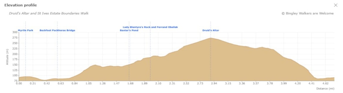
Elevation profile
Route files for GPS & mapping apps
Find out more about these downloadable files and how to use them
Toilets & Refreshments
There are public toilets on this walk and are located on Myrtle Place (by the market square) in Bingley. There are also some free and unattended toilets next to the playground within St Ives Estate.
There are many shops, cafés, restaurants and pubs in town but below are specifics businesses which we recommend if you go on this walk. Feel free to visit their site and contact them.
A traditional Yorkshire pub near Ireland Bridge serving locally renowned beers and great food
A coffee shop near Coppice Pond in the heart of St Ives Estate
Walk Directions - Druid's Altar and St Ives Estate Boundaries Walk
Last edited: 30th May 2026
1. Railway Station to Beckfoot Packhorse Bridge.
Starting at Bingley Railway Station, make your way to Market Square via the alleyway beside Peacock Bar (formerly Foundry Hill Bar). Cross Main Street towards Bingley Arts Centre, then turn left into Myrtle Place, which leads to Myrtle Grove and the entrance to Myrtle Park. Keep left after the cenotaph and playground and head down towards the river. Cross the bridge over the River Aire, follow the alley alongside the allotments and turn right at the end towards the old hamlet of Beckfoot, where you will find the old Beckfoot Packhorse Bridge over Harden Beck.
Note: for more detail on the town centre section of the route, see Discovering Bingley: Walk to Gilstead Crag & Gilstead Moor

Beckfoot Pack Horse Bridge above Harden Beck
2. From Beckfoot to Coppice Pond
Cross Beckfoot Bridge and head up Beckfoot Lane to the busy Harden Road. Cross carefully and go straight into the woods opposite, soon arriving at the lower car park for St Ives Estate. Take the footpath on the right-hand side to avoid the tarmac road, passing Bettys Lodge – a Grade II listed hexagonal building – on your left. Opposite, a path descends into Cuckoo Nest Wood. Follow the path running along the estate edge, overlooking meadows, until you reach a sign for Baxter’s Pond, which is well worth a short detour. Return to the main path and continue uphill until you reach Coppice Pond at the top. You are now back on the main estate road, which can be busy with cars and pedestrians as there is a small car park there.
Note: the Ivy Kitchen café is a short detour from here if you need refreshments.

Coppice Pond is home to many sorts of wildlife
3. Coppice Pond to Lady Blantyre’s Rock
Follow the path to the left which runs along Coppice Pond on your right, home to many ducks and waterfowl that frequent the pond. After a short while, you should find the bird hide on the left-hand side – a good spot for watching the woodland birds of the estate. When you are ready, continue straight ahead on the main path towards the end of the pond. The path veers right and steepens before Lady Blantyre’s Rock comes into view on your left, marked by a commemorative stone. Behind the rock you will find the Ferrand Obelisk, dedicated to William Busfeild Ferrand. Picnic tables nearby make this a sheltered rest stop, though mature trees now block what were once open views.

View of Lady Blantyre's Rock in Bingley St Ives - the wooden carving of the lady doesn't exist anymore
4. Lady Blantyre’s Rock to Druid’s Altar
From Lady Blantyre’s Rock the path climbs steadily until you reach one of the golf course greens, where an opening in the estate wall leads to Altar Lane – with fine views across the Aire Valley. We recommend staying on the path going right inside the walls rather than walking down Altar Lane. After a while you will reach a crossing of paths, go left through another opening in the estate wall.
At this crossroads, take the unsigned path branching off straight ahead through the heather, not Altar Lane on your left which is gated or the farm lane ahead-left. This leads to Druid’s Altar, a prominent gritstone outcrop with wide panoramic views taking in Baildon Moor and Ilkley Moor. Return to the crossroads and continue down Altar Lane towards Bingley.

View from Druid's Altar in Bingley St Ives Estate - Baildon Moor in the background
5. Back in town
Altar Lane is a long descent, steep in places, but with fine views over Bingley along the way. Towards the bottom, after passing the gated entrance to Ravenroyd Estate, turn left onto a path that leaves Altar Lane and reaches Harden Road.
Note: The Brown Cow country pub is directly opposite if you need refreshments.
Cross Ireland Bridge on your left, then take the riverside walk on the right just before Curio Cottage antique dealer, running along the River Aire bank. After passing the Ailsa Spring, take the steps on your left through an opening in the wall, which bring you out at the back of Market Street car park with the old fire station on your left. At the end of the street you reach Main Street. Cross carefully, take Park Road and turn right onto Wellington Street to return to the station.

This path runs along the River Aire in Bingley. It goes from Millgate to Myrtle Park.
St Ives Estate - a National Nature Reserve since 2025
Almost the entire route of this walk falls within the Bradford Pennine Gateway National Nature Reserve, designated in March 2025. St Ives Estate forms a significant part of the reserve, protecting ancient woodland, wetland habitats and species-rich grassland on the edge of Bingley. The ponds, woodland tracks and open parkland you pass through on this walk are not just pleasant scenery – they are actively managed conservation habitats of national importance.
Baxter's Pond - a lifetime's work restored
Baxter’s Pond is a quiet ornamental pond tucked within the estate woodland, believed to have been the swimming pool of the Ferrand family, 18th century owners of St Ives. Long overgrown, it was restored and named in 2005 in honour of John Baxter, a Bradford Council woodland manager who spent his entire working life at the estate and whose idea it was to clear the pond. A small waterfall runs down into it, making it a peaceful spot well worth the short detour.
A Victorian lady's favourite reading spot
Lady Blantyre’s Rock takes its name from the Dowager Lady Blantyre, mother-in-law of William Busfeild Ferrand, who owned St Ives Estate in the 19th century. According to the commemorative stone at the site, she spent nearly 30 summers reading and enjoying the scenery beneath the rock. The 1857 alterations and enlargement of St Ives were designed entirely by Lady Blantyre and her daughter, the Hon. Mrs Ferrand. A wood carving of her figure once stood beside the rock, though this is no longer there.
Behind the rock stands the Ferrand Obelisk, erected by William Busfeild Ferrand (1809-1889) in memory of his mother-in-law. Picnic tables nearby make it a sheltered and peaceful place to stop.
Druid's Altar - views, myths and a future Prime Minister
Druid’s Altar is a prominent gritstone outcrop sitting above St Ives Estate, offering some of the finest panoramic views in the Aire Valley – taking in Baildon Moor, Ilkley Moor and beyond. Despite its name, the rock has no proven druidic connections; the term was commonly applied to striking rock formations during the Romantic era.
The outcrop has a notable literary connection. Benjamin Disraeli, future Prime Minister and close associate of William Busfeild Ferrand, visited St Ives on more than one occasion and used Druid’s Altar as the setting for a dramatic torchlight Chartist meeting in his 1845 novel Sybil. The scene depicts thousands gathering on the moorland around the rock to hear a rousing speech – a vivid fictional echo of the real political tensions of the time.
Frequently Asked Questions
Where is Druid's Altar in Bingley?
Druid’s Altar is a gritstone outcrop situated on the western edge of St Ives Estate, above Altar Lane on the boundary between the estate and open moorland. It sits within the Bradford Pennine Gateway National Nature Reserve and offers wide panoramic views across the Aire Valley towards Baildon Moor and Ilkley Moor. The outcrop is reached via a short detour from Altar Lane during section 4 of this walk.
Is the walk suitable for children?
This walk is suitable for families with older children but is not suitable for prams or pushchairs due to uneven woodland paths and steep sections. The bird hide at Coppice Pond and the varied wildlife throughout the estate make it particularly engaging for children. Druid’s Altar requires close adult supervision as the rocks are uneven and children will be tempted to climb. St Ives Estate also has a large children’s playground, though it is not on the walk route – from the Ivy Kitchen café it is about a 10-minute walk down the estate road.
Can I take my dog in St Ives Estate?
Dogs are very welcome in St Ives Estate. The woodland trails and open spaces offer excellent opportunities for off-lead exercise. Keep your dog under close control in areas frequented by horses and local wildlife, and note that dogs are not permitted to swim in Coppice Pond, which is used by waterfowl and an angling club. The Ivy Kitchen café on the estate is dog-friendly.
What is the connection between the Ferrands and the Busfeilds?
William Busfeild Ferrand (1809-1889), the 19th century owner of St Ives Estate, was born William Busfeild at Cottingley Bridge. His mother Sarah Busfeild inherited St Ives Estate after the death of Edward Ferrand, and both she and her son subsequently changed their surname to Ferrand by Royal Licence. The Ferrands were a long-established local family with Norman roots, while the Busfeilds were a well-educated but less wealthy family from the same area. The two families had been connected for generations before the inheritance brought the estates together under one name.
Who owns Bingley St Ives Estate?
St Ives Estate has been owned by Bradford Council since 1974, when the Council acquired the grounds from Bingley Urban District Council and opened them to the public. A golf course was added at that time, now operated as a private club, and certain buildings and areas of the estate are leased to private businesses. The estate is managed as a public country park and forms a significant part of the Bradford Pennine Gateway National Nature Reserve.
Where can I park for the Druid's Altar and St Ives Estate Boundaries Walk
This walk starts from Bingley Railway Station and we encourage walkers to arrive by public transport where possible. If you are driving, there is a public car park on Wellington Street close to the station. St Ives Estate has four car parks, all charged between 9am and 5pm (£1 per hour up to £4 for over three hours), with free parking for Blue Badge holders. The most convenient for this walk is the bottom car park near the main Harden Road entrance, which the route passes in section 2 – though note you will need to make your own way back to it after descending Altar Lane at the end of the walk. Full details of all four car parks and how to reach the estate by car are on our St Ives Estate page.
Have you done this walk yourself? Don’t hesitate to give us some feedback by leaving a comment below!