Bingley is a small town in West-Yorkshire on the edge of Bradford. Despite a long history of urbanisation and industrialisation, the town remains attached to its green and leafy countryside surroundings. This makes the town a perfect playground and starting point for all sorts of outdoor activities including walking – check our list of Bingley Walks. There are many parks within the town – small and big – and a lot of open spaces outside the town. Most of it being moorlands, woods and fields. Not to forget the many golf courses! In 2016, Bingley Town Council was created and is formed of Bingley, Cottingley, Crossflatts, Micklethwaites, Eldwick and Gilstead. The boundaries are large and go far beyond the urban settings. However, rural settlements like Harden, Cullingworth, Wilsden in the South or East & West Morton in the North can arguably be part of what makes Bingley as a whole.

Enjoying the View - Photo Credit: Marcus Rattray
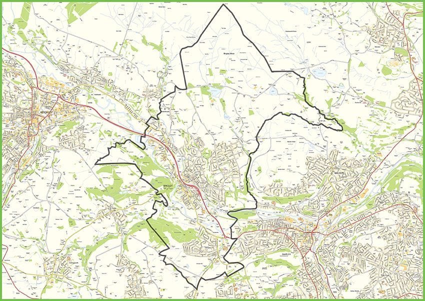
Extend of Bingley Town Council boundaries
Bingley Parks
There are quite a few parks within Bingley and surroundings and most of them will have a play area. All of them are managed by Bradford District Parks.


Other Parks in Bingley and surroundings
Noticeable parks within Bingley and surroundings are:
- Jerr Woods: this is a small natural area hidden away in the Crow Nest neighbourhood of Bingley. There is a play area as well as a small maze and the park is looked after by some local volunteers.
- Gilstead Playing Fields: located opposite the Post Office and not far away from where Sir Fred Hoyle used to live as a young boy. There is a large football pitch and a play area
- Eldwick Playing Fields: located behind the Eldwick Church, it includes a play area as well as a football pitch. It’s also home to the annual Eldwick gala, a fantastic day out for kids and their families.
- Crossflatts Playing Fields: located near the Crossflatts Cricket Club, this little park has a play area and some football pitch.
- Cottingley Park: right in the centre of Cottingley and located near the Cottingley Community Centre, it has a play area and football pitch.
- Harden Memorial Park: located near Memorial Hall which serves as a community centre, this park has a large grass area, some lovely mature trees and a play area. It also hosts the annual Harden Gala, a great community event aimed at children and their families.
- East Morton Playing Fields: located behind the Morton Village Institute, this large grass area also has a play area.
Bingley Open Spaces
There are many spaces within Bingley and surroundings which are accessible to everyone. However, there is a distinction to be made when it comes to “Open Access". The Countryside and Rights of Way Act 2000 (CROW Act) normally gives a public right of access to land mapped as ‘open country’ (mountain, moor, heath and down) or registered common land. These areas are known as ‘open access land’. Below are some of these areas .
Bingley Moor
Bingley Moor is the largest open access land for the area. Located North of Bingley, it’s in fact part of a larger moor called Rombald’s Moor, of which Ilkley Moor is also part of. It’s entirely made of moorland. There are quite a few paths crossing it with long distance walks using them such as The Dales Way, A Dales High Way or The Welcome Way.

To Eldwick, Saltaire & Bingley - Stone signpost on Bingley Moor
Shipley Glen
The geology of Shipley Glen is really fascinating. Connected to Baildon Moor, the area used to be covered by a giant glacier during the ice age. When the glacier started to retreat, Shipley Glen became a massive waterfall for a while. Located on the East side of Bingley, between Gilstead and Baildon, the area is a mix of woodland and moorland and has many paths crossing which are used by long distance walks including A Dales High Way and The Welcome Way.

View of the end of Shipley Glen at the bottom of Baildon Moor
Harden Moor
Harden Moor is located directly to the West of St Ives Estate and Bingley. It also includes Catstones Moor near the village of Ryecroft. It’s mostly made of moorland but the area closest to St Ives is a mix of woodland and open moorland. The entire area is crisscrossed with various paths and if you are lucky enough you might stumble upon a stone circle too!

View towards St Ives Estate and the Aire Valley taken from Harden Moor
Goit Stock
Goit Stock is famously known for its waterfall located on Harden Beck between the villages of Harden and Cullingworth to the South West of Bingley. It’s probably one of the best looking waterfalls in Yorkshire! It’s within a woodland area and most of it is only accessible on foot. We highly recommend our Goit Stock Waterfall Walk starting from Bingley which also includes the Hewenden Viaduct nearby.

A tropical waterfall? No! This is Goit Stock in Harden near Bingley, West Yorkshire