If you are looking for a car free and train walk destination in West Yorkshire, Bingley is definitely one of the best places you can find! Located on the Metro Airedale Line between Leeds/Bradford and Skipton, the town is very accessible from the major Northern cities. Even London is only a step away! And with its sister railway station Crossflatts you are spoiled for choice. Both stations have also recently been adopted by a local community group called Action Stations. We have listed some walks which start from the train stations and if you don’t want to do it yourself, why not join one of the guided walks regularly organised on the line?

View of Bingley Train Station from top of the steps
Journey times to and from Bingley
Both Bingley and Crossflatts railway stations are located in Zone 3 of the West Yorkshire Metro Rail network within easy and direct reach of Leeds or Bradford. To see a map of the train network, go to the Metro website
Local journey times by rail (approximate)
| Trains to Bingley | Travelling time | Change |
|---|---|---|
| Leeds | 18 minutes | No change |
| Bradford | 15 minutes | No change |
| Skipton | 20 minutes | No change |
| Shipley | 6 minutes | No change |
| Saltaire | 4 minutes | No change |
| Keighley | 6 minutes | No change |
| Ilkley | 45 minutes | 1 change |
| Baildon | 20 minutes | 1 change |
| Burley-in-Wharfedale | 35 minutes | 1 change |
In bold are other Walkers are Welcome towns in Yorkshire!
Bingley is also a stop on the Leeds-Settle-Carlisle Line and Bentham Line (Leeds to Morecambe/Heysham Port) therefore connecting the town to the Yorkshire Dales, the Lake District and the West Coast.
Intercity off peak journey times by rail (approximate):
| Trains to Bingley | Travelling Time | Change |
|---|---|---|
| London | 2 hours 40 minutes | 1 change |
| Manchester | 1 hour 20 minutes | 1 change |
| Carlisle | 2 hours 20 minutes | No change |
| Settle | 50 minutes | No change |
| Lancaster | 1 hour 30 minutes | No change |
| Morecambe | 2 hours | No change |
| York | 1 hour | 1 change |
| Sheffield | 1 hour 30 minutes | 1 change |

Bingley and Crossflatts are on the Airedale Line

Click here to download the Map of the West Yorkshire Metro Rail Network (PDF)

Bingley is a stop on the Leeds to Carlisle & Leeds to Morecambe Railway Line
List of train walks from Bingley & Crossflatts Railway Stations
Below is a list of car free train walks starting either from Bingley or Crossflatts railway stations.
| Walk Title | Difficulty | Distance | Start |
|---|---|---|---|
| Bingley & Locks | Timing: approx. 1/2 hour | 1.2 miles - Linear Walk Easy | Crossflatts Railway Station |
| Bingley Five Rise Locks & North Bog – Canal Family Walk | Timing: 1 hour | 2.1 miles - Circular Walk Easy | Bingley Railway Station |
| Crossflatts - Sir Fred Hoyle Walk 2 | Timing: approx. 1 hour and 30 mins | 2.9 miles - Circular Walk Easy | Crossflatts Railway Station |
| Discovering Bingley: Walk to Gilstead Crag & Gilstead Moor | Timing: 1 hour 30 minutes | 3.6 miles - Circular Walk Easy | Bingley Railway Station |
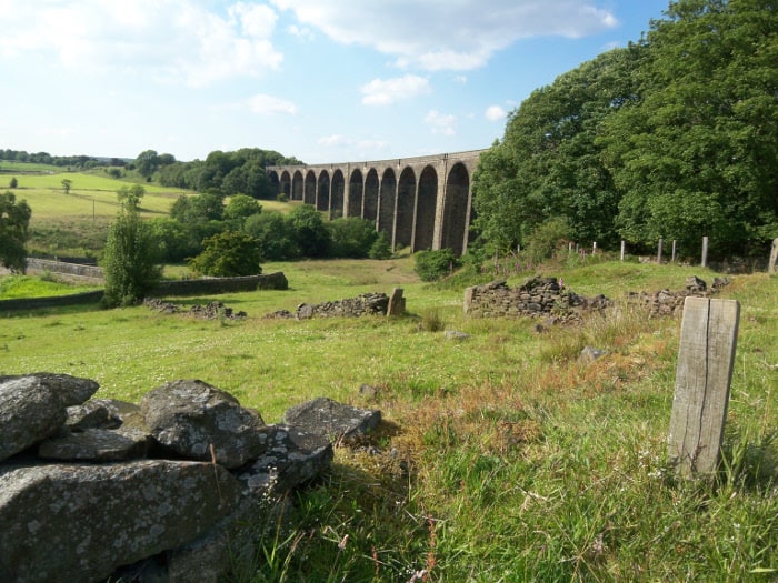
| Between Two Waters: a walk to the Seven Arches Aqueduct | Timing: 1 hour 30 minutes | 4.2 miles - Circular Walk Easy | Bingley Railway Station |
| A Walk Around St Ives Estate Boundaries | Timing: 2 hours | 4.75 miles - Circular Walk Moderate | Bingley Railway Station |
| A ramble in the Harden Valley | Timing: 5 hours | 10.4 Miles - Circular Walk Hard | Bingley Railway Station |
| Ilkley Moor Walk | Timing: 5 hours | 11.8 Miles - Circular Walk Hard | Crossflatts Railway Station |
| The Stanza Stones - Bingley to Ilkley | Timing: 7 to 8 hours | 14.5 Miles - Linear Walk Hard | Bingley Railway Station |

Linear Walk – 1.2 Miles – 1/2 hour
From crossflatts to Bingley along the canal towpath, this family and pram friendly walk is ideal to discover the Five and Three Rise Locks of Bingley. Finish with a nice stroll into town for a deserving break!

Circular Walk – 2.1 Miles – 1 hour
This easy canal walk which features one of the ‘seven wonders of the waterways’ mainly uses the towpath. It is suitable for everyone and is also pram friendly!

Circular Walk – 2.9 Miles – 1 & 1/2 hour
This walk is all about the places where young Sir Fred Hoyle spent time observing the many wonders of engineering and manufacturing factories surrounding Bingley at the time.
Circular Walk – 3.6 Miles – 1 & 1/2 hour
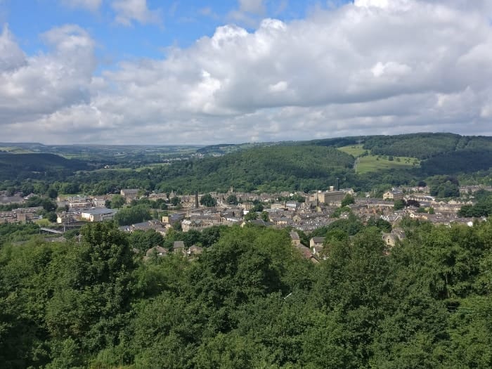
This easy walk will take you all around town on a walk of discovery! It’s one of our favourites and is perfect for first time visitors or residents alike.

Circular Walk – 4.2 Miles – 1 & 1/2 hour
The River Aire and the Leeds and Liverpool canal form an easy to follow route on this walk. You will also see a local architectural wonder known locally as the “Seven Arches Aqueduct".

Circular Walk – 4.75 Miles – 2 hours
St Ives estate near Bingley is a popular destination for all types of leisure activities. It’s a big wooded estate and is owned by the Bradford & City Metropolitan District. This walk will take you all around its boundaries.
Circular Walk – 10.4 Miles – 5 hours
The Harden Valley, in the heart of the Brontë Country is definitely a little gem of a ramble on a nice sunny day! You won’t be disappointed by the variety of features it has to offer: woods, waterfalls, viaduct, moors and of course the views!

Circular Walk – 11.8 Miles – 5 hours
Ilkley Moor is one of the most iconic moors in Yorkshire and there are many features on this walk that might leave you speechless. And of course, the views from the top are quite something!

Linear Walk – 14.5 Miles – 7 to 8 hours
You will visit three stones (Dew Stone, Puddle Stone and Beck Stone) as well as the Poetry Seat. Starting in Bingley with the Five Rise Locks, the gentle towpath walk becomes a climbing up to Rombalds Moor, crossing Ilkley Moor and finishing in Ilkley.
What do they do?
Action Stations is a group of volunteers who have “adopted" Bingley and Crossflatts train stations under the formal Northern Rail station adoption scheme. They aim to involve the community in projects that make everyone proud of their local stations.

What do they do?
The Friends of the Settle Carlisle Line is a rail user group and support group. Originally formed in 1981 to campaign against a proposal to close the route. A decision which was overturned in 1989 when the Government decided that the line must remain open. Since then they have acted as a user group to improve facilities and services for passengers, and as a support group for the train operating companies.

What do they do?
The Friends of DalesRail is a walking society, who specialise in organising and leading guided walks for the general public. Most of these walks use railways in the Yorkshire Pennines; this means that we can easily do linear walks.