Ilkley Moor is one of Yorkshire’s most iconic landscapes – so much so that “On Ilkla Moor Baht ‘at" became the county’s official anthem. This circular walk earns its hard rating: from Crossflatts it heads north through East Morton and past the peaceful reservoir at Sunny Dale, climbing steadily through farmland to the exposed ridge at Keighley Gate. From there the route enters the Bradford Pennine Gateway National Nature Reserve – one of England’s newest NNRs, designated in March 2025 – crossing the open moorland to the 402-metre summit trig point and on to the Neolithic stone circle of the Twelve Apostles. Farmland paths then lead to the legendary walkers’ pub, Dick Hudsons, and down through Lady Lane into Bingley, finishing with the iconic staircase of the Five Rise Locks on the Leeds and Liverpool Canal before the final stretch back to Crossflatts. The views across the Pennines from the top are genuinely worth every metre of the climb.

Summit of Ilkley Moor (402 m) with its triangulation station
Plan your walk
Where to start?
Crossflatts railway station
Keighley Road
Crossflatts
Bingley
West Yorkshire
BD16 2RZ
Grid Reference: SE 103 402
What3Words: ///cabbies.serves.crafted
This is a car-free train walk! We encourage walkers to use public transport, rather than cars, as much as possible.
We have provided an interactive map below, powered by OpenStreetMap. You can zoom in and out, explore the route in detail, follow your live location along the walk, and view points of interest, cafés and facilities directly on the map.
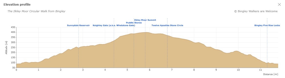
Elevation profile
Route files for GPS & mapping apps
Find out more about these downloadable files and how to use them
Toilets & Refreshments
Unfortunately, there are no public toilets on this walk. The nearest public toilets are located on Myrtle Place (by the market square) in Bingley.
There are many shops, cafés, restaurants and pubs in town but below are specifics businesses which we recommend if you go on this walk. Feel free to visit their site and contact them.
A great countryside pub serving delicious food all year round. They are really walkers and dog friendly so don’t hesitate to pay them a visit on this walk!
A charming little café serving dairy ice cream and located in the former stables of the Five Rise Locks.
Directions - The Ilkley Moor Circular Walk from Bingley
Last edited: 12th May 2026
1. Crossflatts to East Morton: canal towpath and meadows
Starting from Crossflatts Railway Station, turn right onto Keighley Road and cross the bridge over the railway track and bypass – named in honour of Bingley-born astronomer Sir Fred Hoyle. Just after the bridge on your right, look for an opening in the wall leading onto Ivy Mews. Follow the path through this residential area to the intersection and go straight on along Newark Road to Canal Road. Turn right here and you will join the Leeds and Liverpool Canal – one of England’s great working waterways, usually busy with narrowboats moored along this stretch.
Turn left and follow the canal towpath north. Cross the first swing bridge at Micklethwaite Lane and continue to the second at Morton Lane. Turn right over the swing bridge and look for an opening in the wall just after it. This path leads you away from the canal and up through beautiful fields and meadows to East Morton. On entering the village, turn right onto Dimples Lane then left again onto the path between the houses. At the end, you will reach Main Road – turn left and cross almost immediately to join Green End Road opposite.

View of Micklethwaite Bridge on Leeds and Liverpool Canal
One of the waymarkers along the Welcome Way Long Distance Walk
2. Through East Morton to Sunny Dale reservoir
Green End Road is a picturesque stone-terraced street typical of the Pennine villages of West Yorkshire. Follow it past the old cemetery on your right to the end of the village, where the road becomes a track. At the fork, turn left onto Upwood Lane – look for the “Weak Bridge – 13T m g w" sign. The lane follows the wall of the old East Morton Hall on your right. At the three-way fork, keep following the wall and take the first right. At the next intersection go straight on along the track through the fields, which leads you to Sunny Dale woods.
Soon you will see the dam – cross it and take the path into the woods on your left. From here you skirt the edge of the reservoir, following the path as it meanders through the trees. It is a lovely, sheltered spot, quite a contrast to the open moorland ahead. Eventually the path emerges onto a farm track – turn left towards Upwood Hall Farm. Before reaching the farm, take the path on the right to avoid going through it. At the end of this path you will reach Ilkley Road.

Sunny Dale reservoir - a peaceful woodland escape before the moorland climb
3. The high moor: Keighley Gate, the summit and the Twelve Apostles
Turn right onto Ilkley Road, a straight tarmac road that cuts through the moorland fringe, and follow it all the way up to Keighley Gate – also known as Whetstone Gate – where the tarmac ends. You will see the Whetstone Gate communications tower here. Go through the gate and keep right, following the wall along the stone-flagged path onto Ilkley Moor.
The flags beneath your feet tell their own story. In 2012, as part of the Watershed Landscape Heritage Lottery Funded project overseen by Pennine Prospects and supported by the Friends of Ilkley Moor, over 500 tonnes of stone flags were airlifted into place by helicopter – one of the most ambitious moorland footpath restoration projects in the north of England. The aim was to protect strategic routes across the moor and prevent further damage to sensitive habitats. It was actually the second phase of the project: around 300 tonnes had been airlifted the year before.
Along this same stretch, keep an eye out for the Puddle Stones – one of six moorland stones engraved with site-specific poems by Simon Armitage, Poet Laureate, as part of the Stanza Stones Trail. Commissioned by the Ilkley Literature Festival in 2010 and installed in 2012, the trail links six poems on the theme of water carved into stones along a 47-mile walking route from Marsden to Ilkley. Finding the Puddle Stones among the moorland grasses is one of the quieter pleasures of this section.
The path leads steadily to the summit, marked by its unmistakable triangulation pillar at 402 metres – one of the finest viewpoints in West Yorkshire, with the Aire Valley spread out far below and the Pennines stretching to the horizon on a clear day. Continue along the path to an intersection and go straight on. After a short while, turn right to join the Dales Way Link.
You are now close to the Twelve Apostles – a Bronze Age stone circle and one of the most evocative ancient monuments in the north of England, well worth a pause. When you are ready, carry on along the path to a fork and turn right towards the wall, staying on the Dales Way Link. Cross through the gate in the wall and follow the path all the way to Otley Road. As you cross onto Bingley Moor the dramatic moorland landscape gradually gives way to green fields and meadows.

Looking down the Aire Valley from Keighley Gate on Ilkley Moor
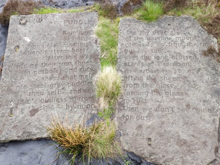
Puddle Stones with poem by Simon Armitage

Stone Circle on Ilkley Moor known as the Twelve Apostles
4. Descending from the moor: Dick Hudsons, Toils Farm and Eldwick
Cross Otley Road with care – traffic moves fast here and visibility from the left is limited. Go right and through the gap in the wall into Dick Hudson’s car park.
Note: at nearly 400 metres after a long moorland crossing, Dick Hudsons is one of the most well-earned pub stops in West Yorkshire. A Walkers are Welcome friendly pub, it has a beer garden with far-reaching views across the valley – hard to leave, but you still have a few miles to go.
After the pub, make your way to the intersection and follow Otley Road in the direction of “Menston, Ilkley" as signed. Keep to the right-hand verge – this is a busy road, so stay alert. After a short while, turn right through a gap in the wall and head across the field towards Toils Farm. In the corner of the field turn right, cross two stiles over the walls and continue across a short field before passing through the farmyard itself. Follow the farm track straight on to Otley Road, then turn left – walking briefly against oncoming traffic, so take care – and after a short while turn right onto a signed public right of way.
This track leads down to Eldwick Beck reservoir. At the bottom, cross the small ford and join the well-laid stone-paved path. At the end of the path turn right towards Tewitt House, then follow the track all the way up to Heights Lane. Cross carefully and go straight on through the wall into the field beyond. Bear right at a 45-degree angle, using the clock tower in the distance as your landmark – this belongs to the former Teacher’s Training School on Lady Lane, a handsome Victorian building now converted into luxury apartments. Once across the field, go right and follow the wall, crossing a couple of stiles before reaching an opening in the wall on your left. Go through it and you are back in a residential area.

Walking down towards Dick Hudsons Pub on Bingley Moor

Looking down at Tewitt Lane in Eldwick
5. Into Bingley: Lady Lane, Gawthorpe Hall and the Five Rise Locks
From College Road turn right up Lady Lane. Once past Dene Bank, look for a gate on the left leading into woodland. A path follows the beck through the trees, with some beautiful garden boundaries alongside. The path emerges onto Oakwood Drive – turn right then left onto Pinedale. At the end of Pinedale, another path leads onto Gawthorpe Drive. Go straight on to find steps leading down to the next path.
Before you do, it is worth a brief detour: turn right at the end of Gawthorpe Drive and you will find Gawthorpe Hall, one of the oldest buildings in Bingley and well worth a look even from the outside, as it remains a private property.
Back at the steps, go down the path to Beck Lane. Turn right and follow the lane alongside the allotment gardens. At the roundabout turn left towards the canal and you will arrive at the top of Bingley Five Rise Locks – one of the finest feats of canal engineering in England, and a fitting finale to a demanding walk. Take a moment to appreciate the staircase of five interconnected lock chambers dropping 18 metres down to the canal below.
Note: the Five Rise Locks Café, located in the former stables beside the locks, is a wonderful place to rest after a long day on the moor. They serve excellent ice cream too.
Once you are ready, walk away from the locks along the towpath. After a short while turn left onto Sleningford Road. Pass the bowling green and continue to the intersection with Ivy Mews – almost exactly where you began. From here it is a short walk back to Crossflatts Railway Station, completing an 11.8-mile circular route that takes in canal, farmland, ancient moorland and one of Yorkshire’s most iconic landscapes.

View of Bingley above Lady Lane and former Teacher Training College

Sunset picture of top of Five Rise Locks with Damart Mill in the background
Other walks on Ilkley Moor
The Friends of Ilkley Moor
The Friends of Ilkley Moor is a voluntary and democratic group composed of people who love Ilkley Moor and want to see it conserved and improved for future generations.
They have a series of heritage walks on their website. We highly recommend to take a look in case you want to further discover Ilkley Moor on another walk!
The Stanza Stones Trail
The Stanza Stones Trail is a 47-mile walking route from Marsden to Ilkley featuring six moorland stones carved with water-themed poems by Poet Laureate Simon Armitage.
The Puddle Stones – one of the six – are found at Whetstone Gate on this very walk, making this a trail you are already partly walking!


The Dales Way & The Dales High Way
Both the Dales Way Link and the Dales High Way pass through the Twelve Apostles stone circle, one of the highlights of this walk. The two long-distance routes briefly share the same path at this point.
The Dales Way Link is a 12.1-mile feeder path from Bradford Cathedral connecting to the main Dales Way, which runs 79 miles from Ilkley to Bowness-on-Windermere. The Dales High Way covers 90 miles from Saltaire to Appleby-in-Westmorland.
The Twelve Apostles stone circle
The Twelve Apostles is a poorly preserved Neolithic stone circle sitting at around 370 metres on the open moorland of Rombalds Moor – one of around 40 prehistoric monuments on Ilkley Moor and part of one of the highest concentrations of ancient remains in northern England.
The circle originally consisted of around 16 to 20 millstone grit boulders, though several have shifted, partially sunk or been damaged over the centuries. Since Victorian times, foot traffic across this exposed and heavily-visited moorland have contributed to that deterioration – a reminder that how we walk here matters. Staying on the flagged paths and resisting the urge to climb or move the stones helps preserve what remains of a monument that has stood for over 4,000 years.
Both the Dales Way Link and the Dales High Way pass through the circle, making it one of the few Neolithic monuments in England that sits at the intersection of two long-distance walking routes.
Rombalds Moor and Ilkley Moor - what is the difference?
Many people use the names Ilkley Moor and Rombalds Moor interchangeably, but there is a distinction worth knowing. Rombalds Moor is the full upland plateau straddling the boundary between the Bradford and Leeds districts of West Yorkshire, covering a large area that includes Ilkley Moor, Bingley Moor, Morton Moor, Burley Moor, Hawksworth Moor, Baildon Moor and Addingham High Moor – each defined by their respective parish boundaries.
Ilkley Moor sits in the northern part of the plateau, with Ilkley town on its northern edge. The 402-metre trig point on this walk is the highest accessible point – one of the finest viewpoints in West Yorkshire. On a clear day, look south to spot the unmistakable silhouette of the Emley Moor transmitting station near Huddersfield, the tallest freestanding structure in the UK at 330 metres.
Dick Hudsons - a pub with a 400-year history
Dick Hudsons has been a waypoint for travellers on Bingley Moor since the 17th century, when it served as a rest stop on the old packhorse trail between Ilkley and Bingley. Originally called The Fleece, the pub was renamed after Dick Hudson, a popular licensee who ran it between 1850 and 1878, and has been at its present site at Highgate Farm since the road down to Eldwick was built.
Today it remains one of the best-known walkers’ pubs in West Yorkshire, a Walkers are Welcome friendly pub with panoramic views over the Aire Valley from its beer garden. The nearest bus stop is at Eldwick Turning Circle, approximately 15 minutes’ walk away, served by First Bus routes 615, 616 and 619 connecting to Bingley and Bradford.
Crossflatts Railway Station - the walk starts here
It was the Victorian railway that first made Ilkley Moor accessible to the working people of Bradford and Leeds – and walkers have been arriving by train ever since. The Airedale Line between Leeds and Skipton opened in 1847, though Crossflatts itself had to wait until 1982 for its own station, built on an entirely new site at a cost of £78,000.
Today three services an hour connect Crossflatts to Leeds in 26 minutes and Skipton in 21 minutes – making this one of the most accessible moorland walks in West Yorkshire by public transport.
Frequently Asked Questions
How high is Ilkley Moor?
The summit of Ilkley Moor sits at 402 metres (1,319 ft) above sea level, marked by triangulation pillar TP-0704 on Rombalds Moor. What many walkers don’t realise is that the trig point sits slightly south of centre on an ancient scheduled monument – a large circular cairn 17 metres in diameter and 0.6 metres high (Historic England list entry 1013472). The cairn material was disturbed when the triangulation pillar was erected, a reminder that the archaeology of this moorland is as fragile as it is ancient. On a clear day the summit offers one of the finest viewpoints in West Yorkshire, with the Aire Valley below and the unmistakable silhouette of the Emley Moor transmitting station visible to the south.
Where can I park for the Ilkley Moor walk?
Crossflatts Railway Station has a large car park, but this is reserved for rail commuters and should not be used for the walk. Free on-street parking is available on Keighley Road and is generally not too busy. Please note that Longwood View is permit holders only – do not park there. Alternatively, arriving by train is a great option: the Airedale Line connects Crossflatts to Leeds in 26 minutes and Skipton in 21 minutes, with three services an hour.
Are dogs allowed for a walk on Ilkley Moor?
The short answer is yes! However, during the ground-nesting bird breeding season (1st March to 31st July) you need to keep your dog on a short lead (defined as less than 2m).
Please note: Bingley is a dog friendly place and many establishments will gladly accept your four legged friend
Is the walk suitable for beginners and families?
This is a challenging walk rather than a beginner’s route – at 11.8 miles with 398 metres of ascent, it is hard-rated and requires a reasonable level of fitness and experience. That said, determined beginners who are well prepared will find it a hugely rewarding introduction to moorland walking.
Moorland weather can change rapidly and without warning, even in summer. Warm sunshine at Crossflatts can mean cold wind, low cloud or rain on the exposed ridge at Keighley Gate. Always check the forecast before setting out, wear sturdy waterproof walking boots and carry warm, waterproof layers regardless of the weather at the start. A map, compass and fully charged phone are strongly recommended.
If you are looking for something less demanding, take a look at our easy and medium-rated walks in Bingley as a starting point before tackling the moor.
Yorkshire's official anthem
“On Ilkla Moor Baht ‘at" – meaning “On Ilkley Moor without a hat" – is the official anthem of Yorkshire, sung in the Yorkshire dialect to the Methodist hymn tune Cranbrook, composed by Thomas Clark in 1805. The words are believed to have been written by members of a Halifax church choir on an outing to Ilkley Moor in the 1850s.
The song tells a darkly comic tale: a young man courts Mary Jane on the moor without a hat, catches his death of cold, is buried, eaten by worms, eaten by ducks – and the singers eat the ducks. As the Wikipedia article puts it, that’s how “we shall all ‘ave etten thee." Circular logic for a circular walk.
The first verse is below – the full lyrics are on Genius if the mood takes you on the summit.
Wheear ‘as ta bin sin ah saw thee,
On Ilkla Moor baht ‘at?!
Wheear ‘as ta bin sin ah saw thee?
On Ilkla Moor baht ‘at?!
On Ilkla Moor baht ‘at?!
"Bradford & Huddersfield - East Calderdale" 288 Map - Cover and Back

"Lower Wharfedale & Washburn Valley" 297 Explorer Map - Cover and Back
Martin Molyneux
We recently did this walk. A quite tough first hour but soon eases afterwards althougn we did set quite a pace. Simple directions to follow . Once on t’tops the views are breathtaking. A nice downhill finish complimented by some lovely houses and gardens. Thoroughly enjoyable few hours
Bingley WaW
Thank you Martin for your lovely comment. We are really glad that you enjoyed this walk and you found the directions easy to follow.