Norr Hill is one of the most rewarding viewpoints in the Bradford district, rising to 262m/859ft above the Aire Valley with sweeping views across West Yorkshire on a clear day. At the summit you’ll find a triangulation pillar – trig point TP-5145 – making this a favourite with trigbaggers as well as walkers who simply come for the panorama.
This 5.9-mile circular walk starts from the centre of Bingley and heads out through the village of Wilsden before climbing up onto the open moorland approach to Norr Hill. The return leg takes you through parts of Cottingley and back along Beckfoot Lane and Myrtle Park, following the River Aire into town. Allow around 3 hours at a steady pace.

View of Bingley in the Aire Valley from Norr Hill summit (262m) with trig point
Plan your walk
Where to start?
Bingley Arts Centre
Main Street
Bingley
West Yorkshire
BD16 2LZ
Grid Reference: SE 106 390
What3Words: ///sprint.colonies.downfield
Bingley Railway Station is only a step away from the start of this walk making it a car-free train walk! We encourage walkers to use public transport, rather than cars, as much as possible.
We have provided an interactive map below, powered by OpenStreetMap. You can zoom in and out, explore the route in detail, follow your live location along the walk, and view points of interest, cafés and facilities directly on the map.
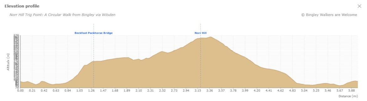
Elevation profile
Route files for GPS & mapping apps
Find out more about these downloadable files and how to use them
Toilets & Refreshments
There are public toilets on this walk and are located on Myrtle Place (by the market square) in Bingley.
There are many shops, cafés, restaurants and pubs in town but below are specifics businesses which we recommend if you go on this walk. Feel free to visit their site and contact them.
Cosy café serving all-day breakfasts, butties, homemade soups, gourmet burgers and classic comfort food!
An independent coffee shop/café serving hot & cold food & drinks with indoor & outdoor seating located on Market Square
Walk Directions - Norr Hill Trig Point from Bingley via Wilsden
Last edited: 18th April 2026
1. Bingley Arts Centre to Beck Foot
Starting in the town centre outside Bingley Arts Centre, to its right is the historical Bingley Market Hall and Butter Cross. Pass this beautiful feature towards a car park and in the bend of Queen Street is the entrance to the Riverside Walk. Go down the steps and at the bottom on the floor you should see a stone plaque with text: “The Throstles Nest of Old England Bingley".
Note: see the walk Discovering Bingley: Walk to Gilstead Crag & Gilstead Moor for more info about the town centre features.
Turn left here and follow the path that runs along the river towards the bottom of Myrtle Park. Then, you should see a green tubular steel bridge. This bridge was erected in 1951 for the Festival of Britain. Cross the bridge and carry on straight up to the wooded area in front of you. Climb the steps and at the top turn left and carry on following the path above the river bank – do not take the path going right. Soon you will be out of the wooded area, go through the narrow hole in the wall and in front of you is a house. Walk in front of the house keeping to the path above the river bank – please be considerate to the house owners and only leave footprints! You should have great views of Myrtle Park. Go down in the field and veer right and soon you should arrive at Beck Foot Pack Horse Bridge, a Grade II listed packhorse bridge over Harden Beck dating back to 1723, wide enough for just a single horse or pedestrian at a time.

Top of Riverside Walk near Queen Street along the Aire River in Bingley

View of Beckfoot Farm and Beckfoot packhorse bridge above the Harden Beck in Bingley
2. From Beckfoot to Wilsden
Don’t cross the bridge, instead stay in the field and go right towards a narrow hole in the wall. You are now on Beck Lane, go up until you see another settlement. Before the first building, take a path going left and crossing the beck. Then you’ll make your way through a golf course – follow the white markings – towards a pine tree plantation (Ruin Bank Wood) on the other side. There is a very steep ascent to start with and then you will arrive at a crossing of paths on Black Hills. Take the path going up on the right then soon after another path on the left towards the edge of the woodland. There, you will have to follow the Millennium Way path and cross various fields up until you reach Lee Lane, a tarmac road. Go left for a short while and take the first path on the right crossing some fields again. When joining another path turn left. Carry on up to another path and turn right there. The path will go down towards a small settlement made of modern timber frame houses. Take left on the track between the houses and at some point you will find yourself at the back of some gardens on a bridge high above Wilsden Beck. After the bridge, you will enter Smithy Lane and you are now in Wilsden.

This path crossing Shipley Golf Course in Bingley connects Beck Lane to a pine tree plantation called Ruin Bank Wood
3. From Wilsden to top of Norr Hill
At the end of Smithy Lane is Main Street. Turn left up the road, keeping on the left hand side. You will pass Manor House Road, Spring Park Road and finally Tweedy Street where you turn left towards Wilsden Primary School. Go to the end of the street, pass the school and between two houses is a footpath. You will go over Wilsden Beck again and then go over a stile above a stone wall. On the other side, go left and follow the wall towards a house in the distance. You will go over two other stiles and then a hole in the wall and arrive on Coplowe Lane in the small hamlet of Norr. Go left, cross the road and immediately after turn right up a track between some houses. The track will turn right and then after the last house just follow a path along a wall going up towards Norr Hill. When the path joins another track, turn left and soon after on the right you will find a small metal gate going in a field. Pass the gate and walk up to the summit of Norr Hill following a broken wall up until you reach the triangulation stone (trig point). Once there, you will have a fantastic view over the Aire Valley, especially Bingley and Baildon Moor. This is probably one of the windiest place in the area by the way! Noticeable feature is the farm windmill which is almost constantly working in the corner of the field, where you will make your way towards for the next stage of this walk.

Millenium Way Path near Wilsden

Path near Norr Hill, Wilsden
4. Norr Hill to Lee Lane
In the corner of the field, near the windmill climb a stile over a wall and follow the path along the dry stone wall. At the end of the path, climb another stile and turn left, with the wall still on your left hand-side. Soon you will see a horse training track covered with recycled shredded carpet bits – quite colourful! Walk down the path up until you reach an opening in the wall with a wooden fence on the other side. Remain on the path between the wooden fence and the dry stone wall and walk down up until a sharp left turn. You should now see some buildings, carry on towards them. You are now behind a stable, turn right turn right to arrive in the courtyard of Lea Ridge Cottage Livery Yard. Pass the house and horse training ground and walk down the track up until you reach Lee Lane.

Windmill on Norr Hill with rainbow in the background
5. Lee Lane to Bradford Road, Cottingley
Cross Lee Lane carefully and go towards the Public Footpath sign opposite. Go through a gate and enter the field. Walk all the way down up until you reach another gate. Carry on up until you see a wall and some buildings. Go right through a narrow hole between walls and walk down the path with a wall on your left-hand side. When you reach a track, go right up until you arrive on March Cote Lane. Turn right and then left on Woodside View. Go all the way up until you arrive on Beckfield Road. Turn right here and again go all the way till the end – notice at some point the entrance to Cottingley Wood Estate on the left. At the end of Beckfield Road is the entrance to a private house but there is a public footpath hidden on the left. This path is really rough with many big rocks and roots. Be careful walking down. At the bottom of the path, turn right on Manor Drive and soon after turn left on a path along a house. You are now on Ghyll Wood Drive. This steep road will take you down to Bradford Road.

Rough Path in Cottingley between Beckfield Road and Manor Drive
6. Bradford Road to Bingley Arts Centre via Myrtle Park
Turn left and walk on the pavement up until you reach Beckfoot Lane – just before Cottingley Bridge.
Note: As you enter Beckfoot Lane, you will find the Willow Bridge Cafe. This is a great place for small refreshments and snacks on this walk
Go all the way until you see the entrance for Shipley Golf Club and veer right remaining on Beckfoot Lane. From there, the tarmac road has no pavement so be careful with oncoming traffic. The Lane will run high above the River Aire and is usually quiet. You will have the Golf Course on your left and when you reach the tennis club, cricket club and football pitch, soon after is a path running between the football pitch on the right and some garden allotments on the left. Walk all the way up until you reach the green steel bridge, you are now in Myrtle Park. Walk your way up the path and go towards the children’s playground. Pass the cenotaph and make your way towards the park entrance. On your left is Bingley Swimming Pool and on your right is Lidl Supermarket. Walk down Myrtle Grove, cross Myrtle Place and you should now see Bingley Arts Centre where this walk ends!
Note: near the Bingley Arts Centre is The Lounge, again perfect place to finish the walk!

Beckfoot Lane is a quiet road which runs above the River Aire. It connects Bradford Road to Beck Foot Pack Horse Bridge and St Ives Estate.

Myrtle Park in Bingley is criss-crossed by many walking paths.
Frequently asked questions
Is there parking near the start of the walk?
The walk starts and finishes at Bingley Arts Centre on Main Street. There is a small car park at the Arts Centre itself, but several public car parks are within a short walk of the start, including the Queen Street Car park. However, Bingley Railway Station is just a few minutes’ walk from the start, making this an ideal car-free train walk. We encourage walkers to use public transport where possible.
How much ascent is there on the Norr Hill walk?
The walk involves around 248 metres of total ascent. The most sustained climb comes on the approach to Norr Hill summit at 262m/859ft, but the route also gains height gradually through the earlier sections crossing the golf course and heading up through Wilsden. The descent back to Bingley is gradual for the most part, with one steeper rough section on the path between Beckfield Road and Manor Drive in Cottingley.
What are the views like from Norr Hill?
The summit of Norr Hill at 262m offers some of the finest panoramic views in the Bradford district. On a clear day you can see across the Aire Valley to Bingley below, out towards Baildon Moor, and across a wide sweep of West Yorkshire. It is also one of the windiest spots in the area, so a layer is worth packing even in summer. At the very top you will find triangulation pillar TP-5145, a favourite landmark for trigbaggers.
Are there cafés or pubs on the Norr Hill walk?
There are two walker-friendly refreshment stops on this route. Willow Bridge Cafe on Beckfoot Lane is perfectly placed towards the end of the walk, serving all-day breakfasts, homemade soups and classic comfort food. Back in Bingley town centre, The Lounge on Market Square is an ideal spot to finish the walk with hot and cold food and drinks. Both businesses proudly support Bingley Walkers are Welcome and display the WaW logo in their window.
What is Beckfoot Packhorse Bridge?
Beckfoot Bridge, also known as the Packhorse Bridge, is a Grade II listed footbridge over Harden Beck dating back to 1723. It is one of the oldest surviving structures in the Bingley area. You will pass it early on in the walk as you follow the River Aire out of town towards Wilsden.
"Bradford & Huddersfield - East Calderdale" 288 Map - Cover and Back
Interesting Facts
- The trig point on the summit of Norr Hill was recently wrapped in blue material and painted with blue NHS letters as a thank you to our health care system during the Covid-19 pandemic. Find out more on the Yorkshire Post.
- Norr Hill used to have coal extraction mining activities which were booming all around the Bradford District in the early first part of the 19th century. Galleries were dug under the hill to extract the black mineral. Find out more on this article from Bradford and District Local Studies
Video
On one of our visits to Norr Hill, we were welcomed by a wonderful rainbow. Take a look at it on the video!
Have you done this walk yourself? Don’t hesitate to give us some feedback by leaving a comment below!