This is a lovely wildlife walk starting from the centre of Bingley, taking you along the River Aire and through the wooded areas of Hollin Plantation and Myrtle Park. The full route is 3.9 miles and can comfortably be done in under two hours, making it one of the best easy walks in Bingley for families and visitors alike.
The first half of the walk follows the River Aire upstream towards Ravenroyd Riding Centre, where fallow deer are regularly spotted grazing close to the path. Keep your eyes on the riverbank too – kingfishers, herons and stoats are all frequent visitors along this stretch, and ducks are ever-present. The second half takes you through beautiful woodland before climbing gently to Altar Lane, where you’re rewarded with sweeping views across the Aire Valley.

Track along River Aire leading towards Ravenroyd Riding Centre
Plan your walk
Where to start?
Bingley Arts Centre
Main Street
Bingley
West Yorkshire
BD16 2LZ
Grid Reference: SE 106 390
What3Words: ///sprint.colonies.downfield
Bingley Railway Station is only a step away from the start of this walk making it a car-free train walk! We encourage walkers to use public transport, rather than cars, as much as possible.
We have provided an interactive map below, powered by OpenStreetMap. You can zoom in and out, explore the route in detail, follow your live location along the walk, and view points of interest, cafés and facilities directly on the map.
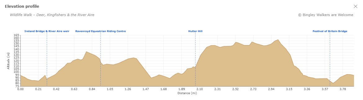
Elevation profile
Route files for GPS & mapping apps
Find out more about these downloadable files and how to use them
Toilets & Refreshments
There are public toilets on this walk and are located on Myrtle Place (by the market square) in Bingley.
There are many shops, cafés, restaurants and pubs in town but below are specifics businesses which we recommend if you go on this walk. Feel free to visit their site and contact them.
A traditional Yorkshire pub near Ireland Bridge serving locally renowned beers and great food
Walk Directions: Wildlife Walk along the River Aire
Last edited: 30th April 2026
1. Bingley Arts Centre to Ireland Bridge along the Riverside Walk
Start outside Bingley Arts Centre in the town centre, with the old covered market and buttercross to your right. Head past this historic feature towards the car park, and at the bend in Queen Street you will find the entrance to the Riverside Walk. Go down the stairs and look for the stone plaque on the floor inscribed with “The Throstles Nest of Old England Bingley" – a lovely piece of local history to set the scene for the walk ahead.
Turn right and follow the path along the river. As you walk upstream, look out for the Ailsa Well sign marking the site of an ancient water spring. Continue along the riverbank until you reach Millgate, then turn left and cross Ireland Bridge – a grade II* listed structure – towards the Brown Cow pub. Just after the bridge, look for a narrow ‘snicket’ between two houses on the opposite side of the road. Cross carefully as there is no pedestrian crossing, follow the path through the houses and turn right back onto the riverbank.

This well is one of the many drinking fountains which used to exist in Bingley.
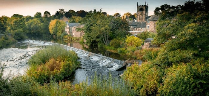
Bingley Church and the River Aire - Photo: Nigel Lumb
2. Up to Ravenroyd Riding Centre: Fallow Deer Country
Back on the riverbank, you will have great views of the Church and the historic old town of Bingley. Follow the track along the river, passing the site of the old gasworks, now replaced by new housing. After the last house the track becomes noticeably more rugged and you will feel like you have left the town behind entirely.
This stretch of the River Aire is excellent for wildlife spotting. Fallow deer are regularly seen grazing in the fields alongside the path, particularly when the trees are not in full leaf. Keep an eye on the river too, as kingfishers are a common sight along this section.
The track eventually veers slightly left away from the river. From here you will see Ravenroyd Riding Centre in the distance. As you approach, signs indicate clearly where to go. Watch out for horses and traffic in the yard, though it is rarely busy.
Track along River Aire leading towards Ravenroyd Riding Centre
3. From Ravenroyd Riding Centre to Marley Farm
Once you pass the last horse training ground, the track becomes rough again. Pass another house before arriving at an open field. Continue uphill until you reach Hutler Hill, a distinctive rounded hillock rising to 101 metres that stands out clearly in the Aire Valley landscape. The origins of the hill are uncertain – it may be a natural glacial feature or something older – but it makes an unmistakable landmark and this is your decision point for the two available routes.
Shorter route: At the hillock, veer left and follow the wall along the edge of the woods. When you reach an old open gate at the wood’s boundary, continue following the wall on your left up to a wooden gate.
Longer route via Marley Farm: At the hillock, turn right through the field towards the railway track. Follow the path alongside the track up to a bridge, then turn sharp left up the hill along a tarmac track leading to Marley Farm. Continue through the farm uphill, then turn left to loop back to the other side of the hillock. You will arrive at the same wooden gate.
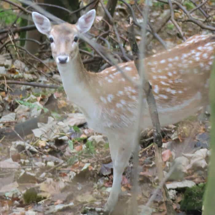
Wildlife along the River Aire - A fallow deer (image courtesy of Paul Langton)
4. Through Hollin Plantation to Altar Lane
At the wooden gate, go through the opening in the wall to the left of the gate (do not open it). Follow the track up through Hollin Plantation, a beautiful mixed woodland sitting high above the River Aire. At the end of the track you will reach a gate into a field – turn left, staying inside the woods, and follow the wall on your right. You are now walking back above the track you came from. At some point the path passes through a gap in the wall; continue through and carry on inside the woods. You will cross a small stream with views down to Ravenroyd Riding Centre below. The path can be muddy here. Rejoin the uphill track when you meet it and follow it to the wood’s edge, where you will find two gates. Take the right-hand gate, passing through the opening on its left-hand side (do not open it).
You are now in an open field with the wall on your left. Horses are usually grazing here so please take care. Follow the path across the field, cross a small stream, and head towards the gate in the distance. From here you will be rewarded with sweeping views across the Aire Valley, with the Pennine hills beyond. Go over the stile on the left-hand side of the gate and you arrive at Altar Lane.

Woodland path through Hollin Plantation above the River Aire, Bingley
5. From Altar Lane back to Bingley Town Centre
Turn left and head down Altar Lane, passing the Ravenroyd Estate Gate, all the way to Harden Road. Take care when you reach Harden Road as traffic can be very busy and fast. Cross carefully over to the other side and follow the path down through the woods.
Note: If you fancy a break at this point, the Brown Cow pub is a short distance to your right along Harden Road, a convenient stop before the final stretch back into town.
Back on the path, as you head down through the woods keep an eye on the trees above the privately owned lake to your left. This is home to a heronry, where herons nest high up in the treetops. It is one of the more unusual wildlife highlights of the walk and well worth pausing to look for the nests on the way through.
After the woods you will find yourself in a open clearance field running alongside the river, which once used to be a horse racing track. Cross the field towards the green steel tubular Festival of Britain Bridge over the River Aire and cross to the other side. You are now in Myrtle Park.
From the bridge, head uphill through the park and take a track passing the basketball court on your right. Keep following the track which will pass behind the former Bingley Town Hall building, then continue through the track to emerge near the entrance of the Wishing Well Nursery. Cross the road into the car park with Bingley Town Council Hub building on your right. Bingley Arts Centre is just on your left, thus completing the walk.
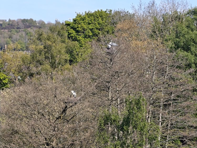
This heronry can be found near the River Aire in Bingley

View of Damart chimney in the background from Myrtle Park on the River Aire bank
Frequently Asked Questions
What wildlife can you see on this walk?
This walk is one of the best in the Bingley area for wildlife spotting. Fallow deer are regularly seen grazing in the fields alongside the River Aire between Ravenroyd Riding Centre and Hutler Hill. Kingfishers and herons are common along the riverbank, and stoats are occasionally spotted too. The walk also passes a heronry near a privately owned lake, where herons nest high in the treetops. Ducks and other waterfowl are present throughout the year.
When is the best time to see deer on the walk?
Fallow deer are most easily spotted in late autumn and winter, when the trees along the River Aire have lost their leaves and visibility across the fields is at its best. Early morning walks tend to offer the best chances, as the deer are more active before the path gets busy. That said, deer have been seen at all times of day and in all seasons, so it is always worth keeping an eye on the fields as you approach Ravenroyd Riding Centre.
Is this walk suitable for dogs?
While dogs are not prohibited on this walk, it is not one we would specifically recommend for dogs. Horses are present in the field above Hollin Plantation and the riverside path can get busy, particularly at weekends. If you are looking for a dog friendly walk in Bingley, our Dog Walks & Dog Friendly Places page has plenty of suitable options.
Is this walk suitable for families and children?
Yes, this is one of Bingley’s most family-friendly walks, though please note that the path includes uneven and rocky sections, making it unsuitable for prams or buggies. The route is 3.9 miles long and can be completed in under two hours at a gentle pace. The terrain is mostly flat along the River Aire, with a moderate uphill stretch through Hollin Plantation. Younger children will enjoy spotting wildlife along the riverbank, and the open fields and woodland sections make it an engaging route for all ages. Sturdy footwear is recommended for all walkers, particularly after rain when some sections can be muddy.
Is there parking near the start of the walk?
The walk starts at Bingley Arts Centre on Main Street, which is well served by public transport, with Bingley railway station a short walk away making this an ideal car-free train walk. For those arriving by car, there is a small car park at the Arts Centre itself. Several public car parks are also within a short walk of the start, including the Queen Street Car Park. Bingley town centre has additional pay and display options nearby too.
What is the Festival of Britain Bridge?
The Festival of Britain Bridge is a green steel tubular pedestrian bridge spanning the River Aire in Myrtle Park, Bingley. It takes its name from the Festival of Britain, the national exhibition held across the UK in 1951 to celebrate British culture and innovation. The bridge is a distinctive local landmark and marks the point where this walk crosses back over the River Aire for the final stretch into Bingley town centre.
What is Hutler Hill?
Hutler Hill is a distinctive rounded hillock rising to 101 metres, located in the fields above the River Aire between Ravenroyd Riding Centre and Hollin Plantation. It stands out prominently in the Aire Valley landscape and serves as the decision point between the shorter and longer route options on this walk. The origins of the hill are uncertain – it may be a natural glacial feature or something much older – and it does not appear to be documented in detail anywhere, which adds to its intrigue as a local curiosity.
Why is it called Ireland Bridge?
Ireland Bridge is a Grade II* listed structure dating from 1686, built to replace an earlier timber crossing, with the parapet added in 1775 and stonemason marks discovered during restoration works in 2010. The origin of its name is disputed, with one theory linking it to Irish mill workers who crossed the bridge to drink at the Brown Cow Inn, and another suggesting that crossing the River Aire here felt as remote as travelling to Ireland itself.
Have you done this walk yourself? Don’t hesitate to give us some feedback by leaving a comment below!
Paul
Had a great walk today thanks to this website. Just searched for ‘see deer near Bingley’ and got this. Thanks, and we did see deer. Have a good photo of a deer if you would like me to send just let me have an email to send to.
Bingley WaW
Thanks so much for your lovely message. We would be delighted to receive your picture and even feature it on this page! I’m sending you an email now.
Mark Trethewey
Today July 17 saw a large group of fallow deer grazing in the field near Ravenroyd. About 12 to 15 of them, well away from the trees, at about 3.30pm.. We got quite close to them, but, as usual, they were nervous and went and hid in adjacent long grass. Beautiful sight while it lasted.
Lynne Smith
A lovely local walk with a bit of everything – riverside, open fields, woodland and great views. Sadly no deer!
Roger Hainsworth
Alternative shorter route: At the hillock veer left and follow the wall along the woods. When you arrive at an old open gate just at the edge of the wood, again follow the wall on your right going up to a wooden gate.
This should say follow the wall on your LEFT going up to a wooden gate
otherwise excellent instructions for a lovely walk.
The fields going up to Altar lane were very muddy 20 November 2020, Walking boots or wellingtons were definitely needed.
Bingley WaW
Oooops! Sorry about this. This has now been corrected. Glad you enjoyed the walk and thank you very much for your feedback.
James
I did this walk today (August bank holiday Monday 28/08/2023) and really enjoyed it. Great instructions, didn’t get lost once. We saw lots of deer too!
Bingley WaW
Thank you James for your kind comment. We are glad you enjoyed the walk and got to see so much wildlife!
Debra Halsworth
We have been on the walk today, it was lovely and we always see deer, but today we had a surprise as in the herd there is a pure white deer! It was amazing to see it running through the trees. Something for your walkers to look out for
Bingley WaW
Thanks Debra! That must be a great sight indeed. Hopefully we can spot it on our next walk!