It’s safe to say that Bingley is not Venice, but with the River Aire running alongside the Leeds & Liverpool Canal for much of this route, you will rarely be far from water. The highlight of the walk is the Seven Arches Aqueduct at Dowley Gap, where the canal is carried 30 feet above the River Aire on a structure engineered by James Brindley. Stand beneath it and you will really feel like you are between two waters.
But the aqueducts don’t stop there: crossing the river at Cottingley, you will also encounter what looks remarkably like a castle bridge. This is in fact the Yorkshire Water Nidd Aqueduct, carrying fresh water from Nidderdale all the way to Bradford, hiding in plain sight above the river. The walk threads together these waterway wonders through Hirst Woods and along a stretch of the Leeds & Liverpool Canal towpath that was fully resurfaced in 2024, making for an easy, rewarding route out of Bingley town centre.

Leeds & Liverpool Canal - The Seven Arches Aqueduct above River Aire
Plan your walk
Where to start?
Bingley Railway Station
Wellington Street
Bingley
West Yorkshire
BD16 2NA
Grid Reference: SE 108 391
What3Words: ///boat.sideburns.comet
This is a car-free train walk! We encourage walkers to use public transport, rather than cars, as much as possible.
We have provided an interactive map below, powered by OpenStreetMap. You can zoom in and out, explore the route in detail, follow your live location along the walk, and view points of interest, cafés and facilities directly on the map.
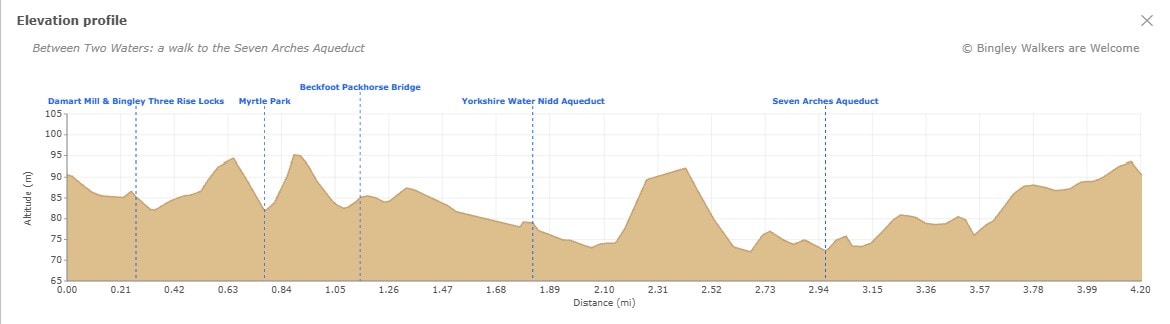
Elevation profile
Route files for GPS & mapping apps
Find out more about these downloadable files and how to use them
Toilets & Refreshments
There are public toilets on this walk and are located on Myrtle Place (by the market square) in Bingley.
There are many shops, cafés, restaurants and pubs in town but below are specifics businesses which we recommend if you go on this walk. Feel free to visit their site and contact them.
An old venue which is a great place to have a drink at the end of your walk.
A lovely café serving coffee & cakes, and brekkies n butties that’ll fill your face!
Located by the canal, this is the perfect place for a drink or food on this walk.
Walk directions: Seven Arches Aqueduct route
Last edited: 8th May 2026
1. Bingley Railway Station to Three Rise Locks
Leaving the station on Wellington Street, turn right towards The Station Masters House. Cross the road and turn right on Park Road, pass Sue Ryder charity shop and then go over the bridge. On the other side, just before the first building on the left, go down towards the Leeds & Liverpool Canal towpath. Follow the canal with Damart Mill on your right hand side up to the Three Rise Locks. Once there, cross over the locks to find yourself on the other side of the canal.
Optional: Here you can carry on along the canal to go and see the Five Rise Locks (see Five Rise Locks Family Walk for more info)

A beam of sunlight reflects from the Damart Mill near Leeds and Liverpool Canal
2. Three Rise Locks to Myrtle Park
Take the pedestrian bridge to cross the bypass named after Bingley-born astronomer Sir Fred Hoyle – you will see Bingley Parish Church on your right. At the traffic lights in front of Bingley Fire Station, cross the street towards The Old White Horse, said to be one of the oldest public houses in England. This is the oldest part of Bingley and still bears some cobbled streets.
Go towards Ireland Bridge and stay on the left-hand side, pass the Curio Cottage Antic Shop and soon after take a path on your left before the bridge. Soon you will find yourself walking along the river. The path is called Riverside Walk and it will take you to Myrtle Park. On the way, you should see a plaque stone in the middle of the footpath with the inscription “The Throstles Nest of Old England, Bingley".

Plaque on riverside footpath with text: "The Throstles Nest of Old England Bingley"
3. Myrtle Park to house above the river bank
At the end of the footpath, a large open space will come into view. This used to be the site of the Bingley Music Live festival from 2007 to 2018. In the distance, you should also see a house high above the river bank – this is where you are heading. Walk across the field towards the pedestrian green bridge over the River Aire, known as the Festival of Britain Bridge. Once on the other side, walk towards the woods and go up some steps. At the crosspath, keep left along the path above the river bank up to the house. Walk in front of the house overlooking the river and the park – please be considerate of the house owners when walking through the grounds and keep to the path.

View of House above River Aire banks in Myrtle Park
4. Towards Beckfoot Lane
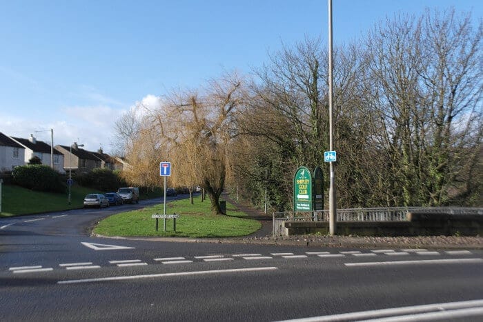
Going down the river bank, soon you will arrive at Beckfoot Packhorse Bridge. The houses on the other side are some of the oldest still standing in the area, dating back to the 17th century. The settlement is said to have links to the Knights Templar, with markings on one of the derelict buildings thought to support that connection. After the settlement, you will find yourself on a tarmac road – Beckfoot Lane – and you should pass along a golf course (Shipley Golf Club). Carry on all the way up to the busy Bradford Road.

Walkers crossing over the Pack Horse Bridge in Bingley (Harden Beck)
5. From Cottingley Bridge to Bradford and Bingley RUFC
At the end of Beckfoot Lane, on your left is Cottingley Bridge going over the River Aire. However, you need to cross Bradford Road to find an opening in the wall on the other side. Be careful while crossing the road, there is no pedestrian crossing there!
Note: Stop for a coffee and a bite at the Willow Bridge Cafe!
Behind the opening in the wall is a steep flight of stairs taking you down into a private garden which has been fenced up on both sides. However the path is a right of way, so you are allowed to cross this private garden. Again be considerate of the garden owners and stick to the footpath. You are finally walking back along the river. Soon you will encounter a strange looking “castle bridge" going over the river. This is part of the Yorkshire Water Nidd Aqueduct, a 32-mile man-made watercourse running from Angram and Scar House reservoirs in upper Nidderdale, North Yorkshire, all the way to Chellow Heights water treatment works in Bradford. Built in the late 19th century, it travels mostly underground – making this dramatic river crossing at Bingley one of the very few places where you can actually see it. It is well worth stopping to take in the scale of the structure before continuing along the river path. Soon after, you will see the Bradford and Bingley “Bees" RUFC training ground.
Entrance to Beckfoot Lane with Cottingley Bridge

A castle over the River Aire? No, this is an aqueduct for Yorkshire Water
6. From Bradford and Bingley RUFC to Hirst Woods
You will skirt the training ground remaining on the path with the river on your left. Notice the Bradford and Bingley Canoe Club’s grade 2 rapid and numerous training gates on River Aire too. After the rubgy training ground, the path follows a new boardwalk installed along the River Aire following flood damage in 2020 – a significant improvement on what was there before. Soon after, you will cross a wooden bridge over Cottingley Beck and then pass under the modern concrete Bingley Relief Road flyover. Continue forward to join a path between high walls just behind the Mercure Bradford Bankfield Hotel. At the end of the walls, carry on following the path with the river on your left, passing under the railway’s Victorian steel pylons just before Hirst Woods. This stretch along the River Aire is one of the quieter and more secluded parts of the walk, offering a contrast to the open canal towpath you will return to shortly.

Airedale Railway Line - Steel Bridge above River Aire in Hirstwood near Bingley
One of the waymarkers along the Welcome Way Long Distance Walk
7. Hirst Woods and back in town
After that bridge, go left along the river and then follow a footpath through the woods. At the end of the path, you should be on the Leeds & Liverpool Canal. Go left and you are now on the Seven Arches Aqueduct – also known as the Dowley Gap Aqueduct – carrying the canal 30 feet above the River Aire. Take a moment to look down at the River Aire below and up at the pitched stone lining beneath each arch, placed there to protect the structure if the river floods. It is also a well-known roosting spot for bats in the summer months. After the aqueduct is a small settlement which used to be warehouse buildings for the canal. The path goes around the settlement and passes the Bingley water treatment works to re-join the Leeds & Liverpool Canal towpath just before Dowley Gap. Stay on the towpath, take in the locks at Dowley Gap, and from there it is all the way back to Bingley along the canal.
Note: You might want to stop at The Fisherman’s Pub, located just after Dowley Gap Locks, for a pint or other refreshments.
To go back to the railway station, you don’t have to walk all the way back to Three Rise Locks. There is a pedestrian bridge above the canal and the bypass which will take you just behind the Aldi store. From there, the station is only a few minutes away.

Moored barge at Dowley Gap near Bingley on Leeds and Liverpool canal - Photo: Nigel Lumb

Leeds & Liverpool Canal - Top of Dowley Gap Locks
Frequently Asked Questions
Who built the Seven Arches Aqueduct and when?
The Seven Arches Aqueduct was engineered by James Brindley and built in the 18th century to carry the Leeds & Liverpool Canal over the River Aire at Bingley. It spans the river on seven stone arches, raising the canal 30 feet above the water. Underneath the arches, pitched stones were laid to protect the structure in case the river floods.
What is the Nidd Aqueduct at Bingley?
The Nidd Aqueduct is a man-made watercourse built by Yorkshire Water to carry fresh water from the Nidd Valley in North Yorkshire all the way to Bradford. It runs mostly underground for its 32-mile route, making its crossing of the River Aire at Bingley one of the very few places where it is visible – appearing as a striking castle-like stone bridge above the river. The entire aqueduct was refurbished in 2017 along with the Barden Aqueduct. Find out more: Victorian Aqueducts Get a Makeover
What is the difference between an aqueduct and a viaduct?
Both are bridge-like structures that cross a valley or river, but they carry different things. An aqueduct carries water – either a canal or a pipeline – while a viaduct carries a road or a railway. The Seven Arches at Dowley Gap is an aqueduct because it carries the Leeds & Liverpool Canal over the River Aire.
Is the Between Two Waters walk suitable for dogs?
Yes, dogs are welcome on this walk. The route follows the Leeds & Liverpool Canal towpath and the River Aire, with plenty of open space along the way. The walk passes through Hirst Woods, which dogs particularly enjoy. Please keep dogs under control near the canal and river at all times.
Is this walk suitable for families and children?
Yes, this is an easy, family-friendly walk of 4.2 miles starting from Bingley Railway Station. The route is largely flat, following the canal towpath and riverside paths. Please note the walk is not suitable for pushchairs or buggies due to some uneven sections and stiles along the route.
Is there parking near the start of the walk?
The walk is designed as a car-free train walk starting from Bingley Railway Station on Wellington Street, and we encourage walkers to use public transport where possible. If you do need to drive, there is parking available in Bingley town centre close to the station such as Wellington Street.
Have you done this walk yourself? Don’t hesitate to give us some feedback by leaving a comment below!