Summary
This is one of our favourite walks for discovering Bingley as a first time visitor or even as a resident. It will take you all around the town on a walk of discovery. Bingley is an old market town and was granted the status in 1212 by King John. It also has a textile industrial heritage which you can't miss in the urban landscape with its many chimneys. However, the most interesting features you will see on this walk are Myrtle Park and Prince of Wales Park, the Leeds and Liverpool Canal with its Five Rise Locks – the town's crown jewel – and the spectacular views from Gilstead Crag or Gilstead Moor, a rugged rock overhanging above Bingley!
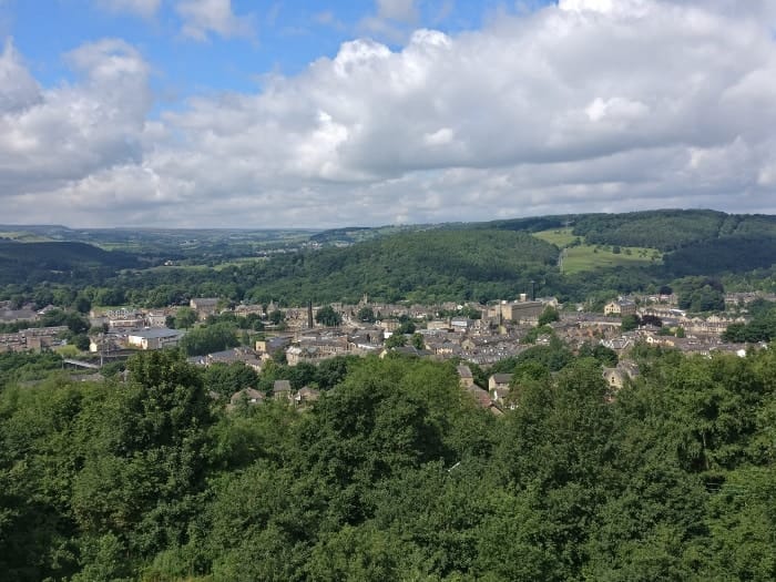
Panorama view of Bingley Town with St Ives Estate and Harden Valley in background. Taken from Gilstead Crag (Gilstead Moor)
Essential info about the walk
Start: Bingley Railway Station
This is a car-free train walk! We encourage walkers to use public transport, rather than cars, as much as possible.
Difficulty: Easy – 1 & 1/2 hours – 3.6 Miles
Toilets: there are public toilets near the start of this walk and are located on Myrtle Place (by the market square) in Bingley.
Refreshments: there are many shops, cafés, restaurants and pubs in town but below are specifics businesses which we recommend if you go on this walk. Feel free to visit their site and contact them.
A traditional Yorkshire pub near Ireland Bridge serving locally renowned beers and great food
A café located near the Five Rise Locks and a great break half way through your walk.
A really nice café and small family business in the heart of Bingley.
Where to start?
Bingley Railway Station
Wellington Street
Bingley
West Yorkshire
BD16 2NA
Grid Reference SE 108 391
Unfortunately, we can't provide the route on an Ordnance Survey Map. Although we have provided digital versions of the track below, we still recommend that you acquire an O.S. Map for backup.
Elevation profile

Downloadable files for mapping applications or GPS devices
Find out more about these downloadable files and how to use them
1. Railway Station to Beckfoot Packhorse Bridge.
Starting from the railway station, make your way towards Market Square via the alley way on the side of Peacock Bar (formally Foundry Hill Bar). Cross Main Street and go towards Bingley Arts Centre. Once there, have a look at the historical Bingley Market Hall and Butter Cross – to the right of Bingley Arts Centre. This reminds us that Bingley is an old market town and was granted the status in 1212 by King John. Then from here, the walk will take you towards Myrtle Park. Go left on a street called Myrtle Place leading towards Myrtle Grove and the entrance of Myrtle Park. You should see Bingley Pool on the right and the new Lidl supermarket on the left. Once in the park, keep the path going left after the cenotaph and the playground and go down towards the river. Cross the bridge over the River Aire, follow the alley along the allotments and once at the end turn right towards an old hamlet. There you will find the old Beckfoot Packhorse Bridge over Harden Beck.
2. Beckfoot Packhorse Bridge to Harden Road
Cross over the packhorse bridge and take a right turn just after it through a hole in the wall to find yourself in a field. Then go up the river bank towards a house at the top. Walk in front of the house keeping to the path above the river bank – please be considerate to the house owners and only leave footprints! Go through the narrow hole in the wall and follow a path in the woods. When you've reached some steps, go right and you should arrive in a meadow close to the river and see a green tubular steel foot bridge. This bridge was erected in 1951 for the Festival of Britain. Do not cross the river on the bridge, stay on its left hand side and walk across the meadow towards a path in the woods which will lead you to Harden Road.

Bingley Arts Centre is located on Town Square
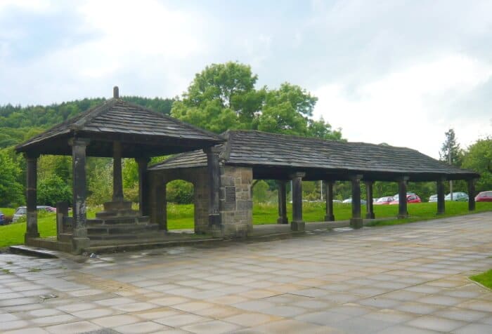
View of the historical Bingley Market Hall and Butter Cross on Market Square

View of Bingley Five Rise Locks from the bottom of Leeds & Liverpool Canal

Allotments on Beck Lane in Bingley near Five Rise Locks

Four different paths at the Prince of Wales Park
3. Harden Road to Five Rise Locks
Once on Harden Road, turn right going down the road towards the Brown Cow pub
Note: Brown Cow pub is a great place to have a drink, so don't hesitate to have a break there!
From there, cross Ireland Bridge over the River Aire towards Main Street. You should see All Saints Church on your left hand side. At the lights, cross the road and turn left, pass the Fire Station and on the right you will find a pedestrian bridge crossing over the bypass which was named after Bingley born astronomer Sir Fred Hoyle. Make your way towards the Leeds and Liverpool canal. Once on the canal, the first set of locks you will see is the Three Rise Locks with the Damart Mill in the background. Go left and follow the towpath, then after the first turn you can't miss the astonishing feature that is the Five Rise Locks – see picture. This set of locks is a unique feature as it’s the tallest staircase locks in the country. It was opened in 1774 and was a key element to the economic development of Bradford’s textile industry. The canal and the locks are now looked after by the Canal & River Trust and if you have a Smartphone, don’t hesitate to scan the QR codes on the information posts they have dotted all around the area. Or take a look at our Bingley Five Rise Locks Family Walk to find out more about this site.
Note: At the top of the locks is the Five Rise Locks café. Another great place for a break and an ice cream!
4. Five Rise Locks to Prince of Wales Park
Cross the Five Rise Locks on the swing bridge, then make your way towards Beck Lane and follow the road with the allotments on your right. This is a residential area full of charm, lovely gardens and quiet alleyways – or snickets as we say locally. Where Beck Lane meets Hall Bank Drive, you will find a snicket opposite leading to Gawthorpe Drive. Once there, on the left you can take a look at Gawthorpe Hall through the gates. This grade II listed building is probably one of the oldest in Bingley. It's a private property, so unfortunately no visit is allowed unless you are authorised.
Then from here it’s all up hills! From Gawthorpe Drive, turn right and make your way towards Spa Lane which leads onto Park Road. Stay on the left hand side and go up the road. Cross Lady Lane and in front of you is the Prince of Wales Park. Opened in 1865 and named after the then Prince of Wales, the future King Edward VII, this park has recently undergone a full restauration. The Friends of Prince of Wales Park are now looking after the park and received many grants to make it what it is today. Well worth a visit!
5. Prince of Wales Park to Gilstead Crag
Go through the park entrance and pass the beautiful lodge. After the bend, turn right and follow a path going up up until you reach a path junction. Carry on straight away towards the park exit. Then you’ll need to cross Parkside road – be extremely careful on this busy road. Opposite are a couple of garages and on the left is a track. Start walking on the track but as soon as you can, take a path going up through the wooded area. This will take you up to Gilstead Crag – also known as Gilstead Moor – where you will finally be able to admire a fantastic view of the Aire Valley on top of it. You should find a bench there for a well deserved break after all this climbing!
Interesting fact: It takes about 2 hours to do this walk and if you time your walk for sunset, on top of Gistead Crag you are in for a treat. It only takes about 15 minutes to finish from there and it’s well-lit.
6. Back to town
Make your way towards the communication tower in the distance, still walking on top of Gilstead Crag. Near the communication tower are a group of rocks high above the valley. Again a fantastic spot for admiring the valley and looking down at Bingley. You will now need to make your way down. Use the path just before the communication tower to find yourself below the the group of rocks and onto a well defined path. Turn right on the path up until you reach a junction, turn left and go down the path with a fence on your right. You should now see some houses and a tarmacked road called Moorbottom Lane. Turn right and the road will soon become a narrow track between gardens. At the end of the track you are now at the junction of Fernbank Drive, Crownest Road and Crownest Lane. Turn right on Crownest Lane and after 30 yards, opposite the road and behind a tall narrow house is the entrance to a snicket – sign posted “Public footpath". Walk down the path, turning left at the bend (don't go through the wooden gate) and carry all the way up until you've reached Belgrave Road. Turn right and then left on Percy Street. Right on Mornington Road and left on Britannia Street. At the bottom, cross the canal and bypass on the pedestrian bridges. After the zebra crossing, turn right onto Ferrand Street where you should see the Aldi supermarket from. Pass the Bingley Five Rise Taxi, cross the car parks and go back towards the train station to finish this walk.
Note: if you are looking for a place to stop for refreshments or something to eat, we recommend The Loft Café Bar, on Main Street only a stone throw away from the train station.

Gilstead Cragg above Bingley has some beautiful moorlands areas

Top of the world - View from Gilstead Crag

Leeds & Liverpool Canal - View of St Ives estate in the background
Have you done this walk yourself? Don't hesitate to give us some feedback by leaving a comment below!
Leave a Reply